Ready for a trip around the world? Head to PrintableWorldMap.net, where all regions are represented and new printable maps were just added.
These maps are perfect for schools or for anyone who enjoys geography and history. Counting the new additions, there are now more than 700 maps at the site, each free to download and print.”
The new maps include 50 state maps with capital cities designated by a distinctive yellow star. There are also several island nation country maps. Plus, find new unlabeled (fill-in) and labeled maps of the original 13 U.S. colonies.
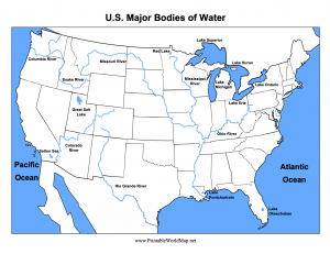
The new topical maps at PrintableWorldMap.net show the major U.S. rivers and bodies of water. The site also has regional maps, continent maps, and much more. Rounding out the collection are maps illustrating time zones, hemispheres, state flags, U.S. statehood, the Oregon Trail, tectonic plates, animal habitats, and zip codes.
PrintableWorldMap.net even has constellation maps of the stars.
Each map downloads instantly for free as a PDF file. Or, you can conveniently download the entire collection at once for $9.